
Good Evening,
A very cold arctic air will be pushed late today towards northern area of Iran, as the Siberian high pressure will be deepening towards northern Eurasia early on Tuesday. This arctic cold air will spread quickly to Iran, Iraq, Kuwait, northern and central Saudi and deserts of Jordan and Syria as well. This will cause a drastic drop on the temperatures during night hours, and possibly wide area frost, and temperatures will reach by -6c over some deserted parts of eastern Jordan.
A very cold arctic air will be pushed late today towards northern area of Iran, as the Siberian high pressure will be deepening towards northern Eurasia early on Tuesday. This arctic cold air will spread quickly to Iran, Iraq, Kuwait, northern and central Saudi and deserts of Jordan and Syria as well. This will cause a drastic drop on the temperatures during night hours, and possibly wide area frost, and temperatures will reach by -6c over some deserted parts of eastern Jordan.
I believe of the risk of this wave! Yes Wednesday into Thursday night, there will be a new injection of cold arctic air spreading to northern Saudi and eastern Syria/Jordan, with possibility for a very low temperatures, and very wide frost, with high possibility for reaching northern Jordan Valley! Again, as last year, frost is threatening us! I think that all because of returning La-Nina.
So, please be aware of this cold wave which will possible leave us by Saturday, as the pattern will drastically change.
What About 27th December?
My colleague Ayman, talked early this week about a new pattern. Actually we are chasing now the birth of cold trough establishing maybe over central Europe, or perhaps Eastern Europe. Models start to show signals that something could be "major" will form as a result of a strong ridging will dominate western Europe, and may extend to north-west Europe. As usual, very difference scenarios are found in the models and at least that there is still 10 days left, but what about 27th December story.
Actually, there isn't any forecaster in the world can predict the exact day of a storm before 12 days, but what am talking about, is that the week beginning of 27th December (27th December to 2/1/2009), is carrying a very high potential for having a strong low pressure system could pull arctic wave to the Middle East, and also pull the snow!
I will discuss in my post this issue, by mixing experimental methods together with real-time forecasts. (Please keep in mind the picture down below)
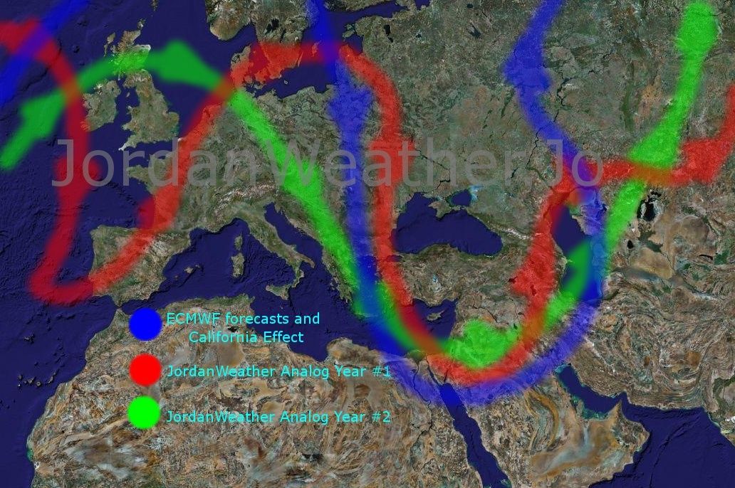
Here we go, 3 reasons are forced me to set my target 27th December, the first reason, as you can notice through the map, that ECMWF mainly storm track was on 00z&12z runs on 15/12/2008 is moving South-east all the way from north-west Europe, resulting Jet stream path way as you can see the blue one. Second reason, is the California effect that Ayman talked about in the previous post.
From my own experiment, some waves that hit the western USA coast and especially California need around 10 days to establish a new pattern in Europe led to a wave hitting us, and from the forecast 17th December an arctic wave will hit western USA coast, so 17+10= 27th December!
Also the blue jet stream of ECMWF has the same path way I think with the California effect.
Third reason is the analogs, JordanWeather has some analogs years, they were used in our seasonal forecast, 2 Analogs years, was being and still monitored specifically as they are having the same patterns like this year since November. The both analogs suggested jet stream path way similar to what we are talking about, and in the same period of 25-31/12/2008, you can notice that through the map above the path ways. The green and red streams are presenting the both analogs.
So?!
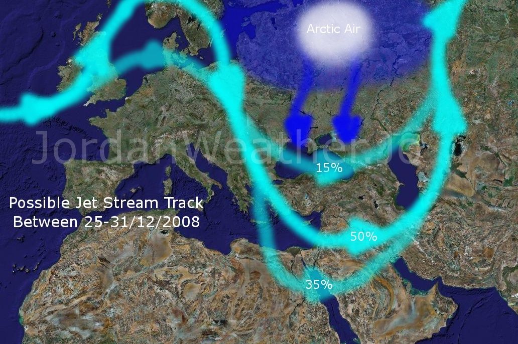
The conclusion is carrying an "Experimental method" forecast, as you can see the map down here; I put 3 possible tracks for the Jet Stream between 25 and 31 December. I believe that we are needing rain urgently as the season average percentage is dropping quickly, so I am not talking about snow defiantly, I am talking about breaking down the relative drought period, but also I can say that the 35% percent Jet Stream path way is enough for snow. What we have now is to wait what will happen, and to pray for rain as soon as possible.
Good Bye,
Mohammed Al-Shaker
3 comments:
Dear Mohammed,
Good luck with this forecast. If it works you are great. I pray to god.
Regards
Hello;
What about Monday 22/12/2008
I think that there is a chance for low pressure system to effect the eastern mediterranean...???
Could you confirm?
WHAT ABOUT 27/12/2008
IS THERE STILL THE CHANCE OF STRONG LOW PRESSURE? IF SO PLEASE UPDATE US
AMMAR FROM LEBANON
Post a Comment