يعتذر موقع طقس-الأردن الإلكتروني عن الخطأ الفني الذي يحصل للموقع و سيعاود البث بصورة طبيعية قريباً
النشرة الجوية و حالة الطقس
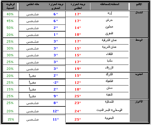
الإصدار: صباح الخميس 26/2/2009
الخميس 2009/2/26:
يطرأ إرتفاع آخر على درجات الحرارة بحيث تصبح أعلى من معدلها لمثل هذا الوقت من العام بقليل، و يكون الطقس نهاراً مشمساً، يتحول في ساعات الليل في شمال و وسط البلاد إلى بارداً و غائماً جزئياً، في حين يتحول "خاصة" في المناطق الجنوبية و الشرقية إلى مغبراً، و يُتوقع أن تتدني مدى الرؤية الأفقية بشكل ملحوظ في ساعات الليل في تلك المناطق. الرياح تكون جنوبية غربية معتدلة السرعة، تنشط أحياناً و تكون مثيرة للغبار في جنوب و شرق البلاد.
هذا و يُحذّر موقع طقس-الأردن الإلكتروني من تدني مدى الرؤية الأفقية في المناطق الجنوبية و الشرقية من البلاد نتيجة تدني مدى الرؤية الأفقية في ساعات المساء و الليل نتيجة الغبار.
* حالة الطقس و درجات الحرارة العظمى نهار اليوم، و الصغرى الليلة القادمة:
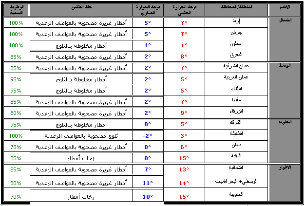
الجمعة 2009/2/27:
تتأُثر المملكة بكتلة هوائية باردة من أصل قطبي، مُصاحبة لتأثير منخفض جوي يتمركز إلى الشمال من جزيرة، بحيث يطرأ إنخفاض ملموس و كبير على درجات الحرارة و تصبح أقل من معدلها لمثل هذا الوقت من العام بحوالي 7-8 درجات مئوية.
صباحاً: يتحول الطقس تدريجياً إلى بارداً و غائماً و ماطراً بإذن الله إبتداءً من المناطق الشمالية تمتد خلال الصباح لباقي المناطق بمشيئة الله، و تكون الأمطار غزيرة في بعض المناطق و مصحوبة بحدوث العواصف الرعدية و تساقط زخات البَرَد، كما و تسقط زخات من الثلج فوق المرتفعات الجبلية العالية التي يزيد إرتفاعها عن 1200متر عن سطح البحر، و تكون الرياح غربية نشطة السرعة مثيرة للعواصف الرملية في المناطق الصحراوية التي لن تتعرض لهطول الأمطار.
ساعات الظهيرة و العصر: يكون الطقس بارداً و غائماً و ماطراً بإذن الله في مختلف مناطق المملكة، مع حدوث العواصف الرعدية و تساقط زخات البَرَد، كما و تتساقط الثلوج و تتراكم بمشيئة الله فوق المرتفعات الجبلية العالية التي يزيد إرتفاعها عن 1200متر عن سطح البحر، في حين أن المرتعفات الجبلية العالية التي يزيد إرتفاعها عن 1000متر عن سطح البحر تسقط عليها زخات من الثلج. الرياح تكون غربية نشطة السرعة مثيرة للعواصف الرملية في المناطق التي لن تتعرض لهطول الأمطار.
ساعات المساء و الليل: يتحول الطقس ليصبح بارداً جداً و غائماً جزئياً إلى غائم، و تسقط الأمطار بإذن الله بين الحين و الآخر خاصة في شمال و وسط المملكة و الأقليم الشمالي من المناطق الجنوبية قد يصحبها حدوث الرعد و تساقط زخات البَرَد، كما و تتساقط الثلوج و تتراكم بإذن الله فوق المرتفعات الجبلية التي يزيد إرتفاعها عن 950متر عن سطح البحر، و تكون الرياح غربية نشطة السرعة، قد يصحبها بعض الهبات القوية أحياناً، و تكون مثيرة للغبار في المناطق الصجراوية.
هذا و يُحذّر موقع طقس-الأردن الإلكتروني من:
-
خطر تشكل السيول نتيجة غزارة الأمطار.
-
شدة العواصف الرعدية، و خطر الإنزلاق نتيجة تساقط زخات البَرَد.
-
خطر الإنزلاق نتيجة تراكم الثلوج بإذن الله فوق المرتفعات الجبلية العالية.
-
خطر تدني مدى الرؤية الأفقية في المرتفعات الجبلية العالية نتيجة الضباب و الغيوم المُلامسة لسطح الأرض، بالإضافة إلى غزارة الهطول.
-
تدني مدى الرؤية الأفقية في المناطق الجنوبية و الشرقية من البلاد نتيجة تدني مدى الرؤية الأفقية في ساعات المساء و الليل نتيجة الغبار.
* حالة الطقس و درجات الحرارة العظمى نهاراً، و الصغرى ليلاً:
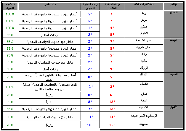
السبت 2009/2/28:
تيستمر تأثر المملكة بكتلة هوائية باردة من أصل قطبي، المُصاحبة لتأثير المنخفض جوي، بحيث تبقى درجات الحرارة أقل من معدلها لمثل هذا الوقت من العام بحوالي 7-8 درجات مئوية، في حين تتأثر المملكة في ساعات ما بعد منتصف الليل بكتلة هوائية باردة من أصل قطبي جديدة.
صباحاً: يكون الطقس بارداً جداً و غائماً جزئياً إلى غائم، و تسقط الأمطار بإذن الله بين الحين و الآخر خاصة في شمال و وسط المملكة و الأقليم الشمالي من المناطق الجنوبية، كما و تتساقط الثلوج و تتراكم بإذن الله فوق المرتفعات الجبلية العالية التي يزيد إرتفاعها عن 1000متر عن سطح البحر، و لكن مع ساعات الصباح المُتأخرة يصبح الهطول الثلجي مخلوطاً بالأمطار، و تكون الرياح غربية نشطة السرعة، قد يصحبها بعض الهبات القوية أحياناً، و تكون مثيرة للغبار في المناطق الصجراوية.
ساعات الظهيرة و العصر: يبقى الطقس بارداً و غائماً جزئياً إلى غائم، و تسقط الأمطار بإذن الله بين الحين و الآخر خاصة في شمال و وسط المملكة و الأقليم الشمالي من المناطق الجنوبية، تشتد مع ساعات العصر و تصبح غزيرة و مصحوبة بحدوث العواصف الرعدية و تساقط زخات البَرَد ، كما و تتساقط زخات من الثلوج بإذن الله فوق المرتفعات الجبلية العالية التي يزيد إرتفاعها عن 1200متر عن سطح البحر، و تكون الرياح غربية نشطة السرعة، قد يصحبها بعض الهبات القوية أحياناً، و تكون مثيرة للغبار في المناطق الصجراوية.
ساعات المساء و الليل: ييستمر الطقس بارداً و غائماً جزئياً إلى غائم، و تسقط الأمطار بإذن الله بين الحين و الآخر في معظم المناطق، و تكون الأمطار غزيرة أحياناً، و مصحوبة بحدوث العواصف الرعدية و تساقط زخات البَرَد ، و في ساعات ما بعد منتصف الليل، يُتوقع أن تتساقط و تتراكم الثلوج بإذن الله فوق المرتفعات الجبلية العالية التي يزيد إرتفاعها عن 1200متر عن سطح البحر خاصة الجنوبية، و تكون الرياح غربية نشطة السرعة، قد يصحبها بعض الهبات القوية أحياناً، و تكون مثيرة للغبار في المناطق الصجراوية.
هذا و يُحذّر موقع طقس-الأردن الإلكتروني من:
-
خطر تشكل السيول نتيجة غزارة الأمطار.
-
شدة العواصف الرعدية، و خطر الإنزلاق نتيجة تساقط زخات البَرَد.
-
خطر الإنزلاق نتيجة تراكم الثلوج بإذن الله فوق المرتفعات الجبلية العالية في ساعات الصباح.
-
خطر تدني مدى الرؤية الأفقية في المرتفعات الجبلية العالية نتيجة الضباب و الغيوم المُلامسة لسطح الأرض، بالإضافة إلى غزارة الهطول.
-
تدني مدى الرؤية الأفقية في المناطق الجنوبية و الشرقية من البلاد نتيجة تدني مدى الرؤية الأفقية في ساعات المساء و الليل نتيجة الغبار.
* حالة الطقس و درجات الحرارة العظمى نهاراً، و الصغرى ليلاً:
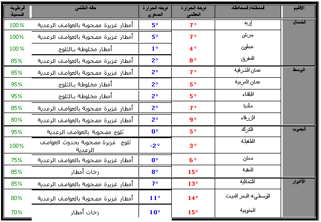
الأحد 2009/3/1:
تتأثر المملكة بكتلة هوائية باردة جديدة قطبية المنشأ، بحيث تبقى درجات الحرارة أقل من معدلها لمثل هذا الوقت من العام بحوالي 7-8 درجات مئوية.
صباحاً: يكون الطقس بارداً جداً و غائماً و ماطراً بإذن الله في معظم المناطق، مع حدوث العواصف الرعدية و تساقط زخات البَرَد، كما و تتساقط الثلوج بإذن الله فوق المرتفعات الجبلية العالية التي يزيد إرتفاعها عن 1000متر عن سطح البحر و تكون أكثر كثافة فوق المرتفعات الجبلية العالية الجنوبية، و تكون الرياح غربية إلى شمالية غربية نشطة السرعة، قد يصحبها بعض الهبات القوية أحياناً، و تكون مثيرة للغبار في المناطق الصجراوية.
ساعات الظهيرة و العصر: يبقى الطقس بارداً جداً و غائماً جزئياً إلى غائم، و تسقط الأمطار بإذن الله بين الحين و الآخر في معظم المناطق، و تكون مصحوبة بحدوث العواصف الرعدية و تساقط زخات البَرَد، كما و تتساقط و تتراكم الثلوج بإذن الله فوق المرتفعات الجبلية العالية الجنوبية، و تكون الرياح شمالية غربية نشطة السرعة.
ساعات المساء و الليل: ييستمر الطقس بارداً بارداً جداً و غائماً جزئياً إلى غائم، و تضعف فرصة الهطول في المناطق الشمالية و الوسطى مع بقائها في المناطق الجنوبية، و تسقط زخات متفرقة من الأمطار بإذن الله بين الحين و الآخر خاصة في المناطق الوسطى و الجنوبية، قد تكون مصحوبة بحدوث العواصف الرعدية و تساقط زخات البَرَد، كما يُتوقع أن تتساقط و تتراكم الثلوج بإذن الله فوق المرتفعات الجبلية العالية الجنوبية، و تكون الرياح شمالية غربية معتدلة إلى نشطة السرعة.
هذا و يُحذّر موقع طقس-الأردن الإلكتروني من:
-
خطر تشكل السيول نتيجة غزارة الأمطار.
-
شدة العواصف الرعدية، و خطر الإنزلاق نتيجة تساقط زخات البَرَد.
-
خطر الإنزلاق نتيجة تراكم الثلوج بإذن الله فوق المرتفعات الجبلية العالية خاصة الجنوبية.
-
خطر تدني مدى الرؤية الأفقية في المرتفعات الجبلية العالية نتيجة الضباب و الغيوم المُلامسة لسطح الأرض، بالإضافة إلى غزارة الهطول.
* حالة الطقس و درجات الحرارة العظمى نهاراً، و الصغرى ليلاً:
هذا و الله أعلم
إعداد: محمد الشاكر "ناشر موقع طقس-الأردن الإلكتروني"
